

INTRODUCTION
Instability of climate conditions during the Last Glacial Termination (LGT) has been interpreted from different geological archives such as sediments from different depositional environments (deep marine, fluvial, lacustrine, aeolian), pollen and other microfossil records, speleothems, and ice cores (e.g., Waelbroeck et al. Reference Waelbroeck, Labeyrie, Michel, Duplessy, McManus, Lambeck, Balbon and Labracherie2002; Rasmussen et al. Reference Rasmussen, Bigler, Blockley, Blunier, Buchardt, Clausen, Cvijanovic, Dahl-Jensen, Johnsen, Fischer, Gkinis, Guillevic, Hoek, Lowe, Pedro, Popp, Seierstad, Steffensen, Svensson, Vallelonga, Vinther, Walker, Wheatley and Winstrup2014; Lane et al. Reference Lane, Brauer, Martin-Puertas, Blockley, Smith and Tomlinson2015). Rapid deglaciation in the Northern Hemisphere resulted in a rebuilding of terrestrial sedimentary environments, especially fluvial and aeolian systems Kasse Reference Kasse2002; Starkel et al. Reference Starkel, Michczyńska, Gębica, Kiss, Panin and Persoiu2015; Zieliński et al. Reference Zieliński, Sokołowski, Woronko, Jankowski, Fedorowicz, Zaleski, Molodkov and Weckwerth2015). The evolution of these depositional systems, together with changes in vegetation cover, governed the quantity and mobility of sediments (e.g., Antoine et al. Reference Antoine, Maunaut, Limondin-Lozouet, Ponel, Duperon and Duperon2003; Kasse et al. Reference Kasse, Hoek, Bohncke, Konert, Weijers, Cassee and Van der Zee2005, Reference Kasse, Vanderberghe, De Corte and Van Den Haute2007; Suther et al. Reference Suther, Leigh, Brook and Yang2018; Johnson et al. Reference Johnson, Hanson, Halfen, Koop, Lancaster and Hesp2020; Swezey Reference Swezey, Lancaster and Hesp2020).
The European Sand Belt (ESB) is a region of abundant Quaternary fluvial and aeolian sediments that extends across northern Europe from Great Britain through the Netherlands, Belgium, Germany, Poland, and the Baltic States (Zeeberg Reference Zeeberg1998; Koster Reference Koster2009; Kalinska-Nartisa et al. Reference Kalińska-Nartiša, Thiel, Nartišs, Buylaert and Murray2015; Bertran et al. Reference Bertran, Bosq, Borderie, Coussot, Coutard, Deschodt, Franc, Gardere, Liard and Wuscher2021). These sediments preserve a record of abrupt climate changes and oscillations such as deglaciations are reflected in the fluvial-aeolian sedimentss of the ESB (e.g., Zeeberg Reference Zeeberg1998). Although the evolution of the terrestrial environment reflected in this stratigraphy has been broadly related to climate changes, current biostratigraphic and lithostratigraphic models reveal considerable discrepancies in comparison to data from marine records and Greenland ice cores (Vandenberghe et al. Reference Vandenberghe, Derese, Kasse and Van den Haute2013). These discrepancies may result from poor stratigraphic models from the ESB, which are mostly based on a few, often uncalibrated, radiocarbon (14C) dates obtained from particular sites, or too few samples being taken from the outcrops without being crosschecked using other methods.
One of the more important elements in fluvial-aeolian sedimentss is paleosols, which have crucial significance for paleoenvironmental reconstructions, as well as for assessing chronology based on 14C dating methods (Kaiser et al. Reference Kaiser, Hilgers, Schlaak, Jankowski, Kühn, Bussemer and Przegiętka2009; Konstantinov et al. Reference Konstantinov, Loiko, Kurasova, Konstantinova, Novoselov, Istigechev and Kulizhskiy2019). The current biostratigraphy used from the Polish part of the ESB is derived from a biostratigraphic model established previously in Denmark (Iversen Reference Iversen1954). Using this model, Konecka-Betley (Reference Konecka-Betley1991) and Manikowska (Reference Manikowska1995) have correlated paleosols with two main climate warmings during the Late Glacial interval—the Bølling interstadial (14.69–14.07 ka) and Allerød interstadial (13.95–12.89 ka). However, more recent results obtained from different parts of the ESB reveal an alternative stratigraphic model that more closely matches Greenland ice core records (Bos et al. Reference Bos, De Smedt Ph, Hoek, Langohr, Marcelino, Van Asch, Van Damme, Van der Meeren, Verniers, Boeckx, Boudin, Court-Picon, Finke, Gelorini, Gobert, Heiri, Martens, Mostaert, Serbruyns, Van Strydonck and Ph2017; Mirosław-Grabowska et al. Reference Mirosław-Grabowska, Obremska, Zawisza, Stańczak, Słowiński and Mulczyk2020; Moska et al. Reference Moska, Sokołowski, Jary, Zieliński, Raczyk, Szymak, Krawczyk, Skurzyński, Poręba, Łopuch and Tudyka2021). Therefore, this study recalibrates the previously published 14C dating results from classic type localities and compares them with more recently published results, as well as new data obtained in this study.
From previously publications, 33 Polish key sites were selected for recalibration (Figure 1A). At every site, at least one paleosol with 14C data occurred within the fluvial-aeolian sediments (Supplementary Table S1). Following recalibration, these dates were compared with more recently published 14C results (Moska et al. Reference Moska, Jary, Sokołowski, Poręba, Raczyk, Krawczyk, Skurzyński, Zieliński, Michczyński, Tudyka, Adamiec, Piotrowska, Pawełczyk, Łopuch, Szymak and Ryzner2020, Reference Moska, Sokołowski, Jary, Zieliński, Raczyk, Szymak, Krawczyk, Skurzyński, Poręba, Łopuch and Tudyka2021) as well as 14C dates obtained from the following six new sites in this study: Brzustów, Gołąb, Laszczyny, Przechód, Osiny, and Teodorów (Figure 1B). Overall, this study aims to (1) collect and recalibrate 14C dating results from selected key sites in the Polish part of the ESB, (2) reinterpret the stratigraphy of these classic sites, and (3) create a new stratigraphic model based on correlation between previous results and new findings from this study.
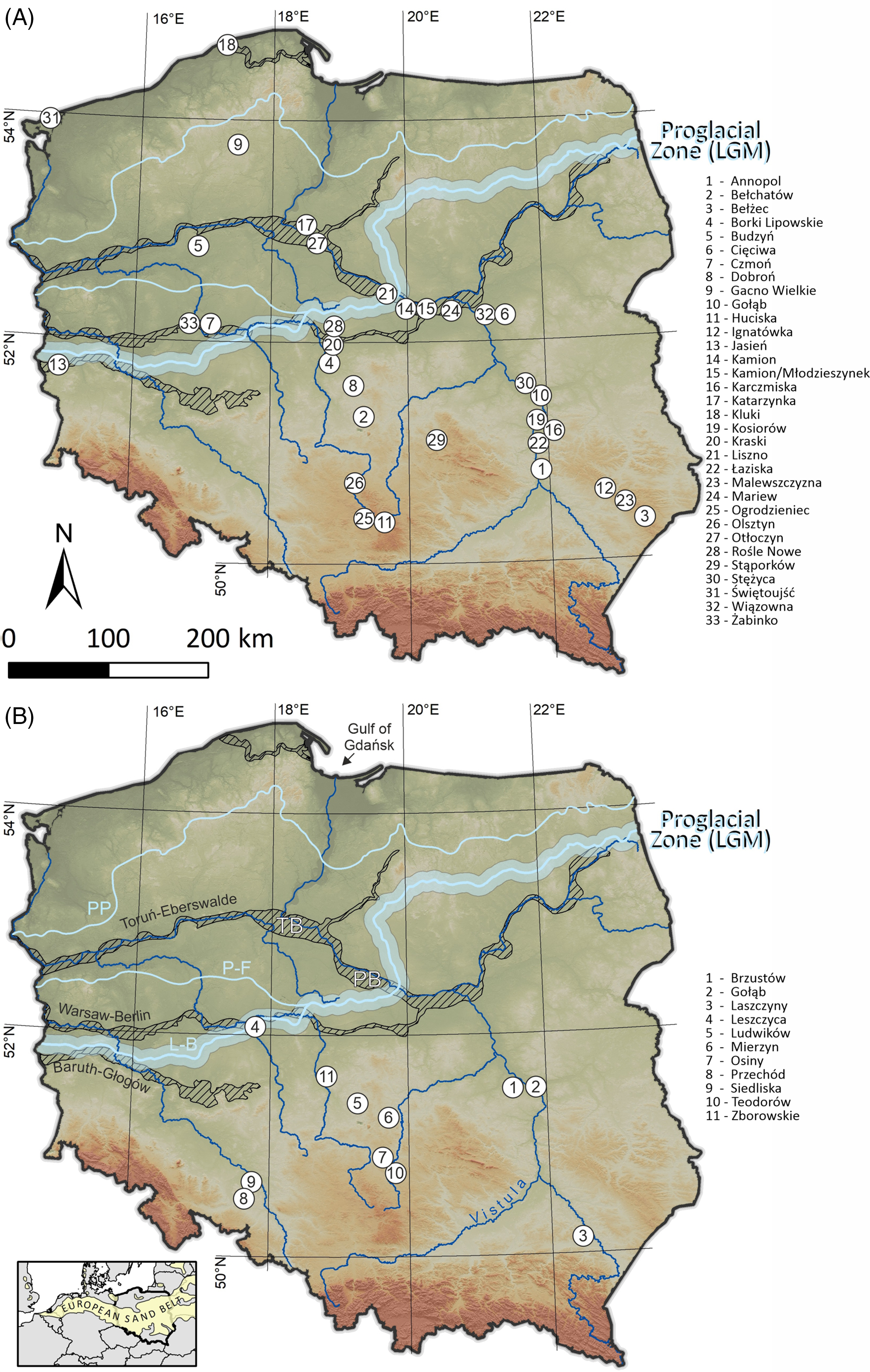
Figure 1 Location map of key sites. Part A is dedicated for investigated radiocarbon samples taken from literature. Part B shows samples made as a part of our project. Explanation of abbreviations: L-B—Leszno-Brandenburg Phase; P-F—Poznań-Frankfurt Phase; PP—Pomeranian Phase; PB—Płock Basin; TB—Toruń Basin.
STUDY AREA AND GEOLOGICAL SETTING
The sites for this study are situated in the Polish lowlands, in the central part of the ESB (Figure 1) and occur in different geomorphological settings (Supplementary Table S1). The fluvial-aeolian sedimentss investigated here are mostly underlain by either Pleistocene sediments of a different origin, or Neogene strata. In relation to the Last Glacial Maximum (LGM), the sites are located in the extraglacial (n = 34), proglacial (n = 4) and glaciated zones (n = 6) of the Late Weichselian stage glaciation (Figure 1). These three zones developed in different ways, dependent primarily on the impact of the Scandinavian Ice Sheet (SIS), as well as the type and quantity of sediment derived from it. The extraglacial zone (EZ) is located between the edge of the mountains and the highlands in the south (the Sudety Mts, the Karpaty Mts, the Kraków-Wieluń Highland and Lublin Highland), and the proglacial zone to the north, and the EZ was not a site of direct deposition of glaciogenic material. The EZ was shaped mostly by the interaction of fluvial, periglacial and aeolian processes throughout the (LGT) (Manikowska Reference Manikowska, Manikowska, Konecka-Betley and Bednarek2002). Fluvial valleys in the EZ were shaped by several phases of incision and aggradation (Starkel et al. Reference Starkel, Michczyńska, Gębica, Kiss, Panin and Persoiu2015), forming fluvial terrace complexes with vast aeolian dune fields on their surfaces (Andrzejewski and Weckwerth Reference Andrzejewski and Weckwerth2010; Weckwerth et al. Reference Weckwerth, Przegiętka, Chruścińska, Woronko and Oczkowski2011). The complete fluvial-aeolian stratigraphy here is characterized by three lithofacies complexes superimposed on each other—fluvial, fluvial-aeolian sensu stricte and aeolian (Zieliński et al. Reference Zieliński, Sokołowski, Woronko, Jankowski, Fedorowicz, Zaleski, Molodkov and Weckwerth2015) and contains several horizons of paleosols.
The proglacial zone (PZ) is located in front of the ice sheet and was shaped and filled by meltwaters that left thick sedimentary deposits. In this zone, outwash plains, fans, and ice-marginal valleys (IMV) are the dominant features. Due to the diachronous extent of the SIS during the LGM and subsequent glacial phases, sedimentary processes began at different times in different locations. The oldest IMVs developed during the Leszno-Brandenburg phase, when the SIS reached its maximum extent in western Poland at ∼23–22 ka (Hughes et al. Reference Hughes, Gyllencreutz, Lohne, Mangerud and Svendsen2016; Tylmann et al. Reference Tylmann, Rinterknecht, Woźniak, Bourlès, Schimmelpfennig, Guillou and Team2019). During deglaciation after the Leszno-Brandenburg phase, the Baruth-Głogów IMV (Figure 1) was formed and filled by glaciofluvial gravels and sands. Towards the east, the SIS reached its maximum later (during the Poznań phase) at ∼20–19 ka (Wysota et al. Reference Wysota, Molewski and Sokołowski2009; Stroeven et al. Reference Stroeven, Hattestrand, Kleman, Heyman, Fabel, Fredin, Goodfellow, Harbor, Jansen, Olsen, Caffee, Fink, Lundqvist, Rosqvist, Stromberg and Jansson2016). The subsequent retreat of the SIS started at ∼17 ka and the Warsaw-Berlin IMV (Figure 1) was formed (Tylmann et al. Reference Tylmann, Rinterknecht, Woźniak, Bourlès, Schimmelpfennig, Guillou and Team2019). The next glacial phase, the Pomeranian phase is dated at 17–16 ka, when the eastern part of the Toruń-Eberswalde IMV was formed (Figure 1). A complex of 11 terraces began to form in the Toruń Basin, partly continuing into the Płock Basin. In the Toruń Basin, the Vistula River changed flow direction from the west to the north and into the Gulf of Gdańsk, leaving the Toruń-Eberswalde IMV, presumably at the end of the Oldest Dryas (∼16.5–14.69 ka) and at the onset of the Bølling interstadial (Weckwerth Reference Weckwerth2010). During the SIS deglaciation after the Pomeranian phase, vast outwash plains were formed to the south of its range.
The glaciated zone Proglacial Zone during the (GZ), located to the north of the LGM (see Figure 1), was shaped first during SIS transgression and subsequently during deglaciation. More recent river incision and aeolian processes have only remodelled the existing surface. Due to ice-sheet cover, aeolian and pedogenic processes started later in the GZ, compared to the EZ and PZ zones (Nowaczyk Reference Nowaczyk1986, Reference Nowaczyk2000; Jankowski Reference Jankowski2012).
MATERIAL AND METHODS
Sedimentology and Sampling
For 14C stratigraphic analysis, 33 key sites with fluvial-aeolian sediments containing paleosols were chosen from previously published works (Figure 1A). At all key sites, basic sedimentological analysis had already been done, and one or more samples for 14C dating had been collected. These previously published 14C ages were tested according to location, reliability of the data, and stratigraphic position within the Late Glacial–early Holocene sediments. Dating results from unconfirmed locations, distinct data inversions, or sources of organic material other than soils, were excluded prior to analysis. At six new profiles reported in this paper (Brzustów, Gołąb, Laszczyny, Osiny, and Teodorów) and five published previously (Moska et al. Reference Moska, Jary, Sokołowski, Poręba, Raczyk, Krawczyk, Skurzyński, Zieliński, Michczyński, Tudyka, Adamiec, Piotrowska, Pawełczyk, Łopuch, Szymak and Ryzner2020, Reference Moska, Sokołowski, Jary, Zieliński, Raczyk, Szymak, Krawczyk, Skurzyński, Poręba, Łopuch and Tudyka2021; Figure 1B) a detailed lithofacies analysis has been performed to identify the sedimentary environments and direction of paleotransport. Due to weak development of specific paleosols and to reduce possibility of contamination by younger (modern) or older carbon, one or more samples for 14C dating were collected from each paleosol (Wohlfarth et al. Reference Wohlfarth, Skog, Possnert and Holmquist1998).
14C Method
Sample preparation for 14C dating focused on retrieving a measurable amount of carbon from generally low-carbon-content sediment, utilizing the fraction that would yield reliable 14C ages. If charcoal was present, then grains were hand-picked, treated with acid-base-acid treatment (0.5M HCl, 0.1M NaOH, 70ºC, followed by rinsing with demineralized water; Piotrowska Reference Piotrowska2013), and dried at 80ºC. For samples where only finely dispersed organic carbon was present, the material was separated using a 150-mm sieve. After acid-base treatment of fine grains, the alkali-soluble humic acid fraction was precipitated by acidification and subsequently dried. The details of preparation for all samples are reported in Supplementary Tables S1 and S2.
Subsamples of the extracted material were packed into tin boats and combusted in a Vario Micro Cube (ElementarTM) elemental analyzer in an automated graphitization equipment (AGE) system (IonplusTM; Wacker et al. Reference Wacker, Němec and Bourquin2010). The obtained CO2 was reduced by reaction with H2 in the presence of an Fe catalyst at 580oC. Oxalic Acid II (U.S. National Institute of Standards and Technology [NIST] Standard Reference Material [SRM] 4990C) was used as a modern reference material, and coal was used as a background material. 14C concentrations in graphite were determined at the DirectAMS Laboratory in Bothell, Washington, USA (Zoppi et al. Reference Zoppi, Crye, Song and Arjomand2007) or the Poznań Radiocarbon Laboratory in Poznań, Poland (Goslar et al. Reference Goslar, Czernik and Goslar2004).
14C ages were calibrated with OxCal software v.4.4.4 (Bronk Ramsey Reference Bronk Ramsey2009) and the IntCal20 calibration curve (Reimer et al. Reference Reimer, Austin, Bard, Bayliss, Blackwell, Bronk Ramsey, Butzin, Cheng, Edwards, Friedrich, Grootes, Guilderson, Hajdas, Heaton, Hogg, Hughen, Kromer, Manning, Muscheler, Palmer, Pearson, van der Plicht, Reimer, Richards, Scott, Southon, Turney, Wacker, Adolphi, Büntgen, Capano, Fahrni, Fogtmann-Schulz, Friedrich, Köhler, Kudsk, Miyake, Olsen, Reinig, Sakamoto, Sookdeo and Talamo2020), reported in Supplementary Table S1. For reporting and discussion purposes, the midpoint of 95.4% probability ranges for calibrated ages are used.
RESULTS
A summary of the lithology and origin of the new profiles in this study is presented in Figure 2. Details from all cited and newly investigated key sites are described in Supplementary Tables S1 and S2. The 14C dating results were obtained from different laboratories during a span of 44 years. Therefore, some of the older cited results have larger uncertainty ranges compared to the results of this study, which have been measured using modern conventional methods. All 14C ages described in this paper have been obtained from soils, mostly from charcoals. Generally, the conventional 14C data obtained between 1977 and 2016 (Supplementary Table S1) have distinctly greater ranges of uncertainty (standard deviation [SD] of the range = 50–700 years) than the accelerator mass spectrometry AMS 14C data (SD range = 50–110 years) from the results of this study (Supplementary Table S2).

Figure 2 Description of the lithology and origin of the investigated profiles.
Statistical analysis of the dating results reveals several peaks of 14C ages concentration (Figure 3). Results show that the level of 14C ages concentration generally decreases with age (i.e., the younger the concentration, the greater is the age). The first peak in concentration is dated to the late Pleniglacial (23.3–14.7 ka b2k), which corresponds with the Greenland Stadial (GS-2.1b/GS-2.1a boundary, Figure 3). The next concentration was distinguished using 5 dating results, with the central mode reaching 13,900 ka b2k, with a range from 13,800–14,000 ka b2k. This concentration occurs in Greenland Interstadial (GI)-1d, just after the Bølling interstadial (14.69–14.07 ka b2k). This data concentration should be treated with some caution for now, and presumably might be related to data located in the Bølling interstadial.
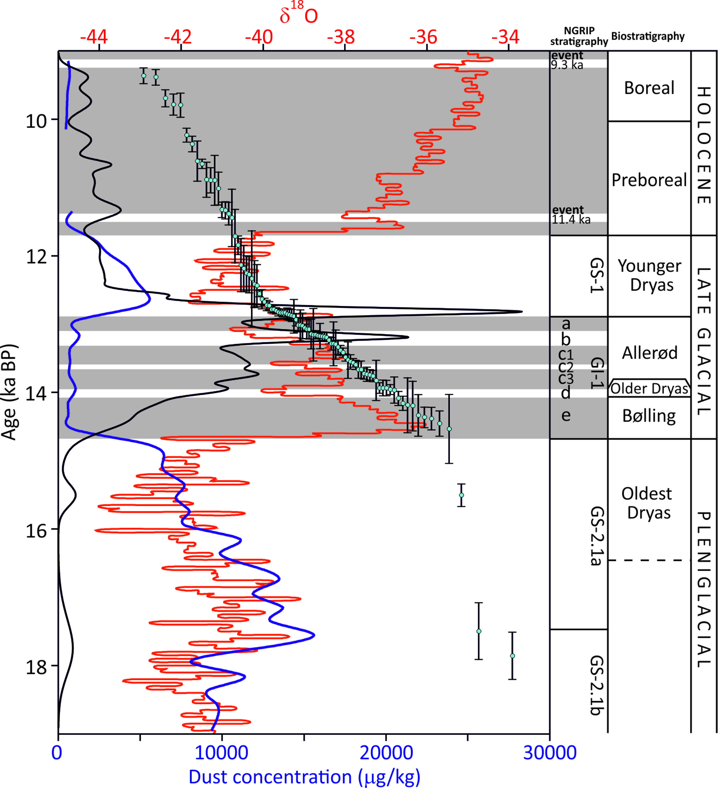
Figure 3 Statistical analysis of the dating results (black curve, analysis were carried out according to probability density distribution function [Berger Reference Berger2010]) compared with the dust concentration (Ruth et al. Reference Ruth, Wagenbach, Steffensen and Bigler2003; blue curve) and records of δ18O (Rasmussen et al. Reference Rasmussen, Bigler, Blockley, Blunier, Buchardt, Clausen, Cvijanovic, Dahl-Jensen, Johnsen, Fischer, Gkinis, Guillevic, Hoek, Lowe, Pedro, Popp, Seierstad, Steffensen, Svensson, Vallelonga, Vinther, Walker, Wheatley and Winstrup2014; red curve), against NGRIP stratigraphy and biostratigraphy. (Please see electronic version for color figures.)
Two 14C peaks are dated to the Allerød interstadial (13.95–12.89 ka cal b2k). An older peak occurs in the upper (younger) part of Greenland Interstadial GI-1-c3, at 13,700 ka cal b2k, based on 15 dating results with a range of 13,400–13,800 ka cal b2k, whereas the younger peak occurs during the final (youngest) part of the second cold climate interval (Greenland Interstadial GI-1-b) at 13,160 ka cal b2k, based on 20 dating results with a range of 13,000–13,300 ka cal b2k.
The largest peak is located within the lower (older) part of the Younger Dryas event (12.89–11.7 ka b2k). This peak is based on 18 dating results and reaches a maximum of 12,780 ka cal b2k, with a range of 12,600–12,900 ka cal b2k. Presence of more than one soil horizon in sediments of Younger Dryas age was recognized at the Jasień and Zborowskie sites (Figure 4), however the limited number of well-dated paleosols prevents further distinction within the stratigraphy.
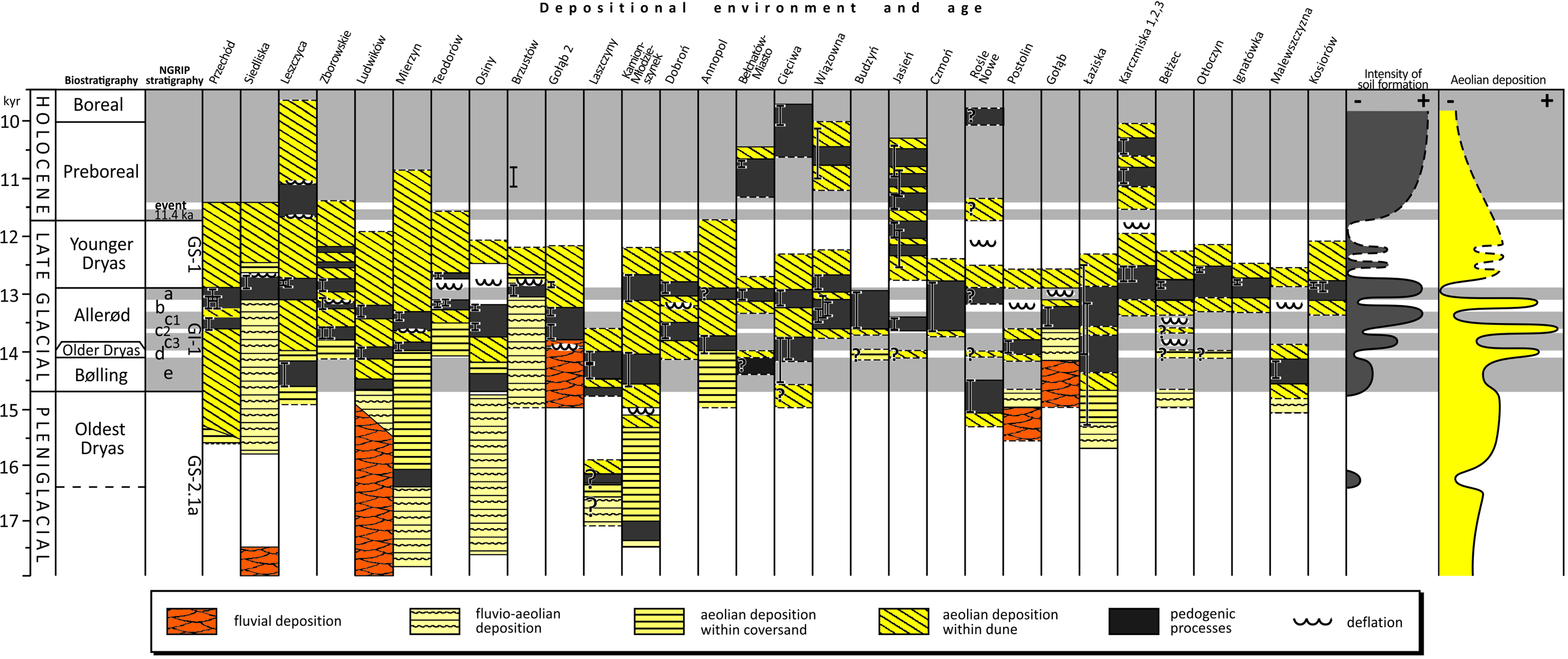
Figure 4 Depositional environment model with main phases of aeolian deposition.
Early Holocene 14C results reveal a bigger distribution of ages in comparison to the results from the (LGT) (Figure 3). One 14C peak is recorded from the onset of the Preboreal stage (11.7–10 ka cal b2k), while the Preboreal/Boreal boundary is characterized by a reduced age range. It is worth noting that the number of the results from early Holocene sediments are considerably smaller than from the Late Glacial. Therefore, all peaks obtained from the Early Holocene should be treated with caution.
Detailed analysis of dating results reveals that soil-forming processes often ceased during the beginning of the subsequent climate cooling, particularly in the Bølling interstadial, following two warm intervals of theAllerød interstadial (Greenland Interstadial GI-1-C1 and GI-1-a, Figure 3). This latency is approximately 50 to 100 calendar years.
DISCUSSION
The findings from this study identified more paleosol horizons in the Late Glacial fluvial-aeolian sediments than has been previously assumed (Manikowska Reference Manikowska1985, Reference Manikowska1991; Nowaczyk Reference Nowaczyk1986). These findings are discussed below in chronological order.
Late Pleniglacial (Greenland stadial GS-2.1b-GS-2.1a, 20.9–14.7 ka cal b2k)
Pedogenic processes before the (LGT) are reported only in a few places. The better dated paleosols are from the Kamion-Młodzieszynek, Stężyca and Wiązowna-Piekiełko sites (Figure 4) and have a late Pleniglacial ages. Manikowska (Reference Manikowska1995, Reference Manikowska, Manikowska, Konecka-Betley and Bednarek2002) and Konecka-Betley (Reference Konecka-Betley2012) correlated paleosols from key sites mentioned above with the Epe warm episode, previously distinguished by Kolstrup (Reference Kolstrup1980). However, comparison with calibrated 14C dating results from sites presented in this study suggest there may have been two pedogenic phases during the late Pleniglacial interval—an older phase, represented by a paleosol at the Kamion-Młodzieszynek site (17.5–17.0 ka cal b2k) and younger phase, documented at the Wiązowna-Piekiełko site (16.0–15.0 ka cal b2k), and presumably detected at the Mierzyn and Laszczyny sites (Figure 4). All these sites are located in the EZ (Figure 1A). During the late Pleniglacial interval, a part of the GZ was still under an icesheet, which hampered soil-forming processes. Simultaneously in the PZ, ice-marginal valleys formed where fluvial aggradation prevailed over incision (Manikowska Reference Manikowska, Manikowska, Konecka-Betley and Bednarek2002; Zieliński et al. Reference Zieliński, Sokołowski, Jankowski, Standzikowski and Fedorowicz2019). Exposed fine-grained terrace deposits were covered with sparse trees and predominantly steppe communities including Cyperaceae and Gramineae, in conjunction with soil formation (Konecka-Betley Reference Konecka-Betley1991). A paleosol with similar age (17.8–15.9 ka cal b2k) was reported from northern Brandenburg, Germany (Gärtner Reference Gärtner1998).
Intensive aeolian processes prevailed during the final part of the late Pleniglacial interval. Aeolian activity limited soil processes to the most favorable places, explaining the scarcity of paleosols from this period. Periglacial phenomena and the formation of gravel lags in areas of aeolian deflation (for instance, the Beuningen Gravel Bed in the western part of ESB; Vandenberghe et al. Reference Vandenberghe, Derese, Kasse and Van den Haute2013) preceded pedogenic processes (Figure 2). Therefore, pedogenic processes during the final part of the late Pleniglacial interval are interpreted as a result of the first distinct warming after climate minimum of the LGM, when pioneering vegetation colonized different types of sediments and tundra-steppe communities developed (Konecka-Betley Reference Konecka-Betley2012; Turner et al. Reference Turner, Tolksdorf, Viehberg, Schwalb, Kaiser, Bittmann, von Bramann, Pott, Staesche, Breest and Veil2013; Bos et al. Reference Bos, De Smedt Ph, Hoek, Langohr, Marcelino, Van Asch, Van Damme, Van der Meeren, Verniers, Boeckx, Boudin, Court-Picon, Finke, Gelorini, Gobert, Heiri, Martens, Mostaert, Serbruyns, Van Strydonck and Ph2017).
Bølling Interstadial (Greenland Interstadial GI-1e, 14.7–14.1 ka cal b2k)
Climate warming at the beginning of the (LGT) caused a return of vegetation and the start of pedogenic processes. Paleosols from this interval have been documented by 14C data from the Leszczyca, Laszczyny, Kamion-Młodzieszynek, Rośle Nowe, Mariew and Malewszczyzna sites (Figure 4). Presumably, soils of Bølling interstadial age are also present at the Ludwików, Osiny, Cięciwa and Łaziska sites (Figure 1), suggesting that there was wider and more frequent preservation of paleosols than previously suggested (Manikowska Reference Manikowska, Manikowska, Konecka-Betley and Bednarek2002). A paleosol from the Annopol site (Figure 1A) was previously thought to be of Bølling interstadial age (Manikowska Reference Kasse2002), but now appears to be younger following recalibration and is coincident with Greenland Interstadial GI-1c3 (Figure 4). Paleosols of Bølling interstadial age are generally absent in the western part of the ESB, where relatively low abundance of paleosols from this interval is explained by subsequent erosion and redeposition of organic material (Figure 3). This interpretation is supported by the presence of only organic layers recorded from the Netherlands (Kolstrup Reference Kolstrup2007). During this time, deposition of aeolian sediments designated as Older Coversand II and the Lower Loamy Bed prevailed (Vandenberghe et al. Reference Vandenberghe, Derese, Kasse and Van den Haute2013; Kasse and Aalbersberg Reference Kasse and Aalbersberg2019). The absence paleosols of of Bølling interstadial age is also noted in northeast Germany (Kaiser et al. Reference Kaiser, Hilgers, Schlaak, Jankowski, Kühn, Bussemer and Przegiętka2009, Reference Kaiser, Schneider, Küster, Dietze, Fülling, Heinrich, Kappler, Nelle, Schult, Theuerkauf, Vogel, de Boer, Börner, Preusser, Schwabel, Ulrich, Wirner and Vogel2020), similarly explained by more recent erosion/redeposition (Kappler et al. Reference Kappler, Kaiser, Küster, Nicolay, Fülling, Bens and Raab2019). Only in the Reinberg Basin of northeast Germany is a paleosol reported from the onset of the Bølling interstadial, with a 14C age ∼14.7 ka cal b2k (de Klerk et al. Reference De Klerk, Helbig, Helms, Janke, Krügel, Kühn, Michaelis and Stolze2001). It is possible that paleosols of Bølling interstadial age may have been preserved to the west of Poland. For example, 14C dates from the Lower Saxony area in east Germany (46 to 28 ka cal BP; Mol Reference Mol1997) reveal the presence of paleosols of this age.
Detailed analysis of 14C dating results suggest that an interruption of soil processes took place 50–100 calendar years after the Bølling interstadial. This time lag presumably resulted from the delayed onset of aeolian sediment mobilization due to the gradual disappearance of plant communities. It is worth noting that locally (at the Cięciwa, Laszczyny and Łaziska sites, see Figure 4) vegetation cover persevered despite climate cooling, and soil processes continued. The Older Dryas (14.07–13.95 ka cal b2k), which is correlated with Greenland Interstadial GI-1d, was a time of climate cooling when vegetation did not change significantly (Mirosław-Grabowska et al. Reference Mirosław-Grabowska, Obremska, Zawisza, Stańczak, Słowiński and Mulczyk2020), however there was reduced pine-birch forest and an increased abundance of herbaceous communities. These vegetation data emphasize the minor role of aeolian processes during the Older Dryas and the importance of local conditions, (such as groundwater level, geomorphology, and permafrost) in the persistence of pedogenic processes.
Early Allerød Interstadial (Greenland Interstadial GI-1c3, 13.95–13.66 ka cal b2k)
Climate warming at the beginning of the Allerød interstadial stopped aeolian sediment deposition. Sandy ridges were recolonized by plants, stimulating the return of pedogenic processes. Paleosols of this age have been found at the Zborowskie, Mierzyn Gołąb, Rośle Nowe, Postolin, Gacno Wielkie, Cięciwa, and Annopol sites (Figure 4). These sites are located mostly in the EZ, whereas the Gacno Wielkie site is in the GZ (Figure 1). The distribution of paleosols of this age suggests that favorable conditions during the early Allerød interstadial facilitated soil development across the whole ESB in Poland. Paleosols from the time of Greenland Interstadial GI-1c3 are reported from the central part of the ESB, but they are rare (Kaiser et al. Reference Kaiser, Hilgers, Schlaak, Jankowski, Kühn, Bussemer and Przegiętka2009; Kappler et al. Reference Kappler, Kaiser, Küster, Nicolay, Fülling, Bens and Raab2019). In the western part of the ESB, conditions were favorable for the development of vegetation (Crombe et al. Reference Crombe, Van Strydonck, Boudin, Van den Brandem, Derese, Vandenberghe, Van den haute, Court-Picon, Verniers, Bos, Verbruggen, Antrop, Bats, Bourgeois, De Reu, De Maeyer, De Smedt Ph, Van Meirvenne and Zwertvaegher2012, Reference Crombé, Bos, Cruz and Verhegge2020; Bos et al. Reference Bos, De Smedt Ph, Hoek, Langohr, Marcelino, Van Asch, Van Damme, Van der Meeren, Verniers, Boeckx, Boudin, Court-Picon, Finke, Gelorini, Gobert, Heiri, Martens, Mostaert, Serbruyns, Van Strydonck and Ph2017). No 14C data are reported from the early part of the Allerød interstadial. Presumably soil processes continued throughout the entire Allerød interstadial, but available data from the western part of the ESB represent only the final episode of the late Allerød interstadial (Vandenberghe et al. Reference Vandenberghe, Derese, Kasse and Van den Haute2013; Kasse and Aalbersberg Reference Kasse and Aalbersberg2019). In the Polish part of the ESB, pedogenic processes were interrupted by an intensification of aeolian processes and cold conditions during the early Allerød interstadial (GI-1c2). A similar increase in aeolian sediment deposition during Greenland Interstadial GI-1c2 has been reported from Belgium (Crombe et al. Reference Crombé, Bos, Cruz and Verhegge2020). Presumably, sudden climate drying and wildfires mobilized considerable amounts of sand and caused vegetation cover to disappear from aeolian dune ridges. It is possible that intensive river incision occurred during the (LGT) and drying of newly formed terraces played a considerable role in sediment supply (Kozarski et al. Reference Kozarski, Gonera, Antczak, Lang and Schluchter1988; Vandenberghe et al. Reference Vandenberghe, Kasse, Bohncke and Kozarski1994; Vandenberghe Reference Vandenberghe2008; Kasse et al. Reference Kasse, Van Balen, Bohncke, Wallinga and Vreugdenhil2017). River incision could have caused a reduction of vegetation cover, mobilization of sand and an increase of aeolian sediment deposition during the next cold interval (Greenland Interstadial GI-1c2).
Middle Allerød Interstadial (Greenland Interstadial GI-1c1, 13.6–13.31 ka cal b2k)
The second warm interval during the Allerød interstadial resulted in the return of vegetation in areas with aeolian sediments. Paleosols from this interval have been detected at the Gołąb, Jasień, Świętoujść, Ludwików, Mierzyn, Osiny, and Przechód sites (Figure 1). Presumably in the other 8 key sites (Budzyń, Czmoń, Gacno Wielkie, Łaziska, Olsztyn, Przechód, Teodorów, Zborowskie) soil processes continued until the next cold interval, which coincides with Greenland Interstadial GI-1b (Figure 4). The abundance and degree of soil development (Moska et al. Reference Moska, Sokołowski, Jary, Zieliński, Raczyk, Szymak, Krawczyk, Skurzyński, Poręba, Łopuch and Tudyka2021) suggests that conditions were favorable for vegetation. This assumption is supported data from several sites in the central and western parts of the ESB where palynological analyses indicate that pine-birch forests prevailed with considerable abundance of willow shrubs and grasses (Bos et al. Reference Bos, De Smedt, Demiddele, Hoek, Langohr, Marcelino, Van Asch, Van Damme, Van Der Meeren, Verniers and Crombé2018; Krüger and Damrath Reference Krüger and Damrath2020; Mirosław-Grabowska et al. Reference Mirosław-Grabowska, Obremska, Zawisza, Stańczak, Słowiński and Mulczyk2020). In the western part of the ESB, soil-forming processes continued from the early Allerød interstadial until the middle Allerød interstadial, whereas in the central part they were interrupted by aeolian activity during the Greenland Interstadial GI-1b. Similar pedogenic processes have been interpreted from sediments of this age in southwest Siberia, Russia (Konstantinov et al. Reference Konstantinov, Loiko, Kurasova, Konstantinova, Novoselov, Istigechev and Kulizhskiy2019). This large geographic range suggests that pedogenic processes developed across the whole ESB.
Late Allerød Interstadial (Greenland Interstadial GI-1a, 13.1–12.9 ka cal b2k)
Paleosols from the last warm interval in the Allerød interstadial have been documented at numerous sites (Figure 4), as indicated in the data concentration model (Figure 3). Uncertainty remains over whether part of these paleosols that have been dated to the beginning of the Younger Dryas (Greenland Stadial GS-1) represent a continuity of pedogenic processes from the late Allerød interstadial, or whether they were stopped in association with enhancement in aeolian activity. Distinct increases in soil formation processes have been interpreted from sediments of this age at northeast Germany (central part of ESB, Kaiser et al. Reference Kaiser, Hilgers, Schlaak, Jankowski, Kühn, Bussemer and Przegiętka2009; Kappler et al. Reference Kappler, Kaiser, Küster, Nicolay, Fülling, Bens and Raab2019). In the western part of the ESB, Greenland Interstadial GI-1a is interpreted as being a main soil-forming period when a paleosol of Usselo-type formed (Vandenberghe et al. Reference Vandenberghe, Kasse, Hossain, De Corte, Fuchs and Murray2004, Reference Vandenberghe, Derese, Kasse and Van den Haute2013; Kasse and Aalbersberg Reference Kasse and Aalbersberg2019).
In Poland, paleosols formed in all zones (Figure 1). In the GZ, GI-1a interval was the main soil-forming phase was coincident with Greenland Interstadial GI-1a and finished more or less at the onset of the Younger Dryas, whereas in the EZ, soil continued to form during the beginning of the Younger Dryas (Figure 4). This difference might have been caused by the zoning of the climate and the impact of the SIS. Alternatively, this difference may have resulted from differences in the development of river valleys in the GZ, where there was more intensive incision of rivers and a greater supply of sandy material (Andrzejewski and Weckwerth Reference Andrzejewski and Weckwerth2010; Jankowski Reference Jankowski2012).
During the late Allerød interstadial (13.1–12.9 ka cal b2k) soils formed under climate conditions and vegetation cover that was similar to previous warm intervals of the Allerød interstadial. Pine-birch forests formed on the sandy substratum in the aeolian dune areas with a mixture of grasses and herbs (Błaszkiewicz et al. Reference Błaszkiewicz, Piotrowski, Brauer, Gierszewski, Kordowski, Kramkowski, Lamparski, Lorenz, Noryskiewicz, Ott, Słowinski and Tyszkowski2015; Bos et al. Reference Bos, De Smedt, Demiddele, Hoek, Langohr, Marcelino, Van Asch, Van Damme, Van Der Meeren, Verniers and Crombé2018). Gradual decreases in the extent of forests, which were being replaced by tundra communities with juniper and herbaceous plants, was typical for the Younger Dryas and suggests a delay of paleoenvironmental response to climate changes at the Allerød/Younger Dryas boundary. These events took place mainly in the EZ. In the GZ, however, the change of climate conditions is more obvious in the paleosol chronologies (Katarzynka and Żabinko sites, Figure 4). Local factors such as deep and fast river incision might have played an important role. Both the Warta River and the Wisła (Vistula) River started to cut into the substratum during the Bølling-Allerød interstadial and formed several terraces (Kozarski et al. Reference Kozarski, Gonera, Antczak, Lang and Schluchter1988; Weckwerth et al. Reference Weckwerth, Przegiętka, Chruścińska, Woronko and Oczkowski2011). Vast aeolian dune fields formed on these terraces, enhancing the considerable input of sandy material and fast response of the environment to climate change (Andrzejewski and Weckwerth Reference Andrzejewski and Weckwerth2010; Jankowski Reference Jankowski2012).
Younger Dryas (Greenland Stadial GS-1, 12.9–11.7 ka cal b2k)
Distinct and rapid climate cooling at the onset of the Younger Dryas is inferred from European Lowlands (Theuerkauf and Joosten Reference Theuerkauf and Joosten2012; Słowiński et al. Reference Słowiński, Zawiska, Ott, Noryśkiewicz, Plessen, Apolinarska, Rzodkiewicz, Michczyńska, Wulf, Skubała, Kordowski, Błaszkiewicz and Brauer2017; Kasse et al. Reference Kasse, Woolderink, Kloos and Hoek2020). Climate cooling during this time resulted in a change of river characteristics, regrowth of permafrost and rebuilding of vegetation cover (Vandenberghe Reference Vandenberghe2015; Petera-Zganiacz and Dzieduszyńska Reference Petera-Zganiacz and Dzieduszyńska2017; Bos et al. Reference Bos, De Smedt, Demiddele, Hoek, Langohr, Marcelino, Van Asch, Van Damme, Van Der Meeren, Verniers and Crombé2018). In the western part of the ESB these changes seem to have been faster and more far-reaching in comparison to the central part of the ESB. The data presented in this paper suggest a delayed response of pedogenic processes (as outlined above) to climate change at numerous sites, particularly in the EZ. Results from northeast Germany also suggest that locally, paleosols could have been preserved from at least the beginning of the Younger Dryas (Kappler et al. Reference Kappler, Kaiser, Küster, Nicolay, Fülling, Bens and Raab2019). In the western part of the ESB, however, soil-forming processes were interrupted by aeolian activity at the Allerød/Younger Dryas transition (Vandenberghe et al. Reference Vandenberghe, Derese, Kasse and Van den Haute2013; Kasse and Aalbersberg, Reference Kasse and Aalbersberg2019).
Locally, soil-forming processes started again in the middle and late part of the Younger Dryas (Figure 4). The initiation and cessation of soil-forming processes are interpreted as responses to Younger Dryas climate fluctuations (Rasmussen et al. Reference Rasmussen, Bigler, Blockley, Blunier, Buchardt, Clausen, Cvijanovic, Dahl-Jensen, Johnsen, Fischer, Gkinis, Guillevic, Hoek, Lowe, Pedro, Popp, Seierstad, Steffensen, Svensson, Vallelonga, Vinther, Walker, Wheatley and Winstrup2014), when local factors (such as slope orientation, humidity, presence of permafrost) could favor plant recolonization on aeolian dune slopes and the development of soils.
Early Holocene (Preboreal-Boreal, 11.7–9.6 ka cal b2k)
Paleosols from the early Holocene are reported from the Bełchatów, Cięciwa, Huciska, Jasień, Karczmiska, Kluki, Liszno and Ogrodzieniec sites. This geographic distribution suggests that pedogenic processes took place in all zones across Poland. Dating results do not reveal a particular chronostratigraphic relation with cool events from 11.4 ka and 9.3 ka, as reported by Rasmussen et al. (Reference Rasmussen, Bigler, Blockley, Blunier, Buchardt, Clausen, Cvijanovic, Dahl-Jensen, Johnsen, Fischer, Gkinis, Guillevic, Hoek, Lowe, Pedro, Popp, Seierstad, Steffensen, Svensson, Vallelonga, Vinther, Walker, Wheatley and Winstrup2014). Aeolian activity which interrupted soil-forming processes appeared only locally, and was induced by local factors (e.g., wildfires, river incision, and formation of terraces) as well as by human activity (Hirsch et al. Reference Hirsch, Schneider, Nicolay, Błaszkiewicz, Kordowski, Noryskiewicz, Tyszkowski, Raab and Raab2015; Kasse et al. Reference Kasse, Tebbens, Tump, Deeben, Derese, De Grave and Vandenberghe2018). Palaeosol data from the early Holocene seems to be largely independent of climatic trends and vegetation changes.
CONCLUSIONS
Detailed analysis of 14C dates from previously published literature, as well as results obtained more recently and in this study, supports the following conclusions:
Fluvial-aeolian sediments reveals more sensitivity to climate intervals than previously assumed. This paper distinguishes two pedogenic periods during the late Pleniglacial interval, as well as three pedogenic periods related to warm intervals during the Allerød interstadial and at least one pedogenic period from the Younger Dryas. Pedogenic periods were interrupted by aeolian activity during cold climate intervals. A peak of 14C data which could be related to the Bølling interstadial, is more likely to be related to the cold interval that is coincident with Greenland Interstadial GI-1d (Older Dryas).
The highest 14C peak from the older phase was 12.8 ka cal b2k, which coincides with the GI-1a/GS-1. This 14C peak resulted from the shorter time of exposure to erosional processes than previous 14C peaks.
-
There is a time lag of 50–100 calendar years between the development of vegetation cover and pedogenic processes in relation to climate changes.
-
Considering the position of paleosols in specific profiles, we observe that a parts of the paleosols were preserved during cold intervals, particularly during the Allerød interstadial. This interpretation suggests a significant role of local conditions, e.g., groundwater level, presence of permafrost, and the intensity of aeolian process.
-
Soil-forming processes during the early Holocene were only interrupted by aeolian processes on a local scale, without any clear relation to climate intervals. It is assumed that this interpretation also related to local factors, including human activity.
SUPPLEMENTARY MATERIAL
To view supplementary material for this article, please visit https://doi.org/10.1017/RDC.2022.37
ACKNOWLEDGMENTS
This study is a contribution to scientific project financed by the National Science Centre, Poland – No. 2018/30/E/ST10/00616. Publication was supported under the rector’s pro-quality grant. The Silesian Technical University grant number grant 14/020/RGJ22/0018.


